

Gallery
Unique manuscript describing European cities in the 18th century
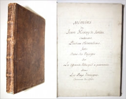
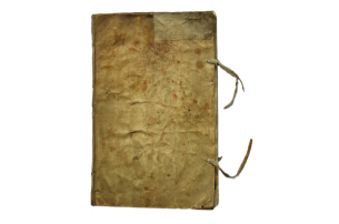
Sandoz-Rollin, Jean-Henri de - Memoires de Jean Henry de Sandos. Contenant, plusieurs observations, faites dans ses voyages sur les differentes villes qu'il a parcourries dans Les Pays Etrangers. Europe, 1730. 4to [264 x 185 mm]. Manuscript. Leather binding. (1) 315 pages.
sold

Baroque Bible illustrations by a woman artist
Catharina Sperling-Heckel
(Augsburg 1699 - 1741 Augsburg)
315 wash ink drawings for the Old Testament.
Highly important collection of Baroque biblical illustrations by a woman artist.
sold/verkauft
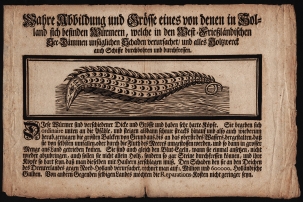
Unique copy of an 18th century zoological broadside depicting a shipworm
Jean Rousset de Missy (1686-1762) [after] - Wahre Abbildung und Grösse eines von denen in Holland sich befinden Würmern, welche in den West-Frießländischen See-Dämmen unsäglichen Schaden verursachet, und alles Holtzwerck auch Schiffe durchbohren und durchfressen. (Deutschland, c. 1733) - The only known copy of this broadside about the shipworm (Teredo Navalis).
sold/verkauft
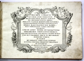
Very rare baroque anthology for organ music
1) FISCHER, Johann Caspar Ferdinand - Blumen Strauss aus dem anmuthigsten musicalischen Kunst Garten des Hochberühmten Herrn Iohann Caspar Ferdinand Fischers... Augsburg, Johann Christian Leopold, n.d. (c.1735) Folio - bound with: 2) GASS, Felix - David Ludens ad arcam Dei. Augsburg, Johann Christian Leopold, n.d. (c.1735) (4), 30, (2) pp. - bound with: 3) TORNER, Joseph Nicolaus - A.B.C. Per tertiam Minorem. Augsburg, Johann Christian Leopold, n.d. (c.1735) (4), 48, 23 pp.
Exceptional anthology with three almost undiscoverable organ books.
sold
A French scientific expedition to Lapland
OUTHIER, Reginaud - Journal d'un voyage au Nord, en 1736. & 1737. Paris, Piget & Durand, 1744. In-4. With 16 engraved plates and maps and some woodcut vignettes. Contemporary full calf, spine with five raised bands, richly gilt and with title label.
sold
Early 18th-century scrapbook
Scrapbook with about 84 cut-out images from engraved prints by Martin Engelbrecht. France, n.d. (c. 1740). Contemporary vellum.
sold
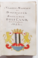
Dutch armorial manuscript for the region of Delfland in South Holland
Naamen en Wapenen der Dykgraaven en Hoog Heemraaden van Delfland: van soo Oude tyden als deselven te vinden syn, tot deese. Armorial manuscript from c. 1740. Drawings and handwriting in pen, ink and watercolor. With 164 coats of arms.
sold/verkauft
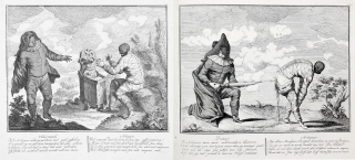
Commedia dell’Arte
XAVERY, Gerard Joseph - Het Italjaansch Tooneel Voortreffelijk in 16 verbeeldingen uytgevoert, Verrijkt met Nederduytsche en Fransche vaarzen. - Bound with: Het nieuw geopend Italiaans Toneel, vertonende de wonderlijke ziekte bezwangerheid en baring van Arlequin: benevens de opvoeding van des zelfs Jongen Zoon. Amsterdam, Petrus Schenk II, c. 1740. Folio [360 x 255 mm]. Contemporary vellum binding. Engraved titles, 16 engraved plates (each).
sold/verkauft .
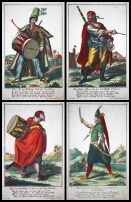
Trenck’s Pandurs
ENGELBRECHT, Martin - Collection of 21 engraved plates of Slavonian Pandurs. Augsburg, n.d. [c. 1742]. Folio (348 x 220 mm).
verkauft / sold

RAMMELSBERG, J. W. - Beschreibung aller sowohl noch heutiges Tages florirenden als bereits verloschenen Geist- und Weltlichen Ritter-Orden in Europa. 10. Tle. und Anhang in 1 Bd. Bln., 1743/44. 4to. Leder der Zeit mit Ruckenschild und Rückenvergoldung., Gest. Frontispiz, Titel, 20, 140 Seiten, mit 33 Kupfertafeln.
sold/verkauft

Schöner Sammelband mit zwei sehr seltenen Werken über Kometen
Äusserst seltener Sammelband mit zwei sehr seltenen Werken über Kometen - 1) Conrad Lycosthenes - Die Wunder Gottes in der Natur, bey Erscheinung der Cometen, Oder besondere Anmerckung der vornehmsten Cometen, oder Strobel-Sterne. -- Frankfurt und Leipzig, 1744 -- 184 Seiten, mit gest. Frontuispiz und 41 Kupfertafeln (mit 83 Kupfern); 2) Gesammlete Nachrichten von Cometen. -- Frankfurt und Leipzig, 1744 -- 1 Bl., 85 Seiten
sold/verkauft

Collection of wooden draughts-pieces from the 18th century
24 wooden draughts-pieces. Nuremberg, c. 1745. Material: wood. Diameter: 49 mm.
sold
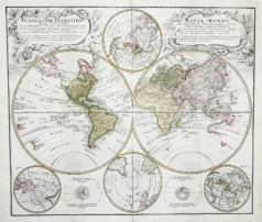
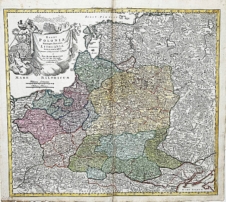
Rare old colored world map by Johann Homann from 1746
HOMANN, Johann - "Planiglobii Terrestris Mappa Universalis / Mappe-Monde qui represente les deux Hemispheres". Nürnberg, 1746. Original altkolorierte Kupferstich-Karte. Blatt-Maße: ca. 50,5 x 60,5 cm.
sold/verkauft
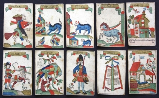
A rare 18th-century witch game
Hexenspiel. (The Witch game). (Munich)?, circa 1750/1760. (probably Franz Xaver or Franz Joseph Fetscher). 32/32 playing cards. 90 x 60mm; Hand-coloured woodcuts.
sold/verkauft
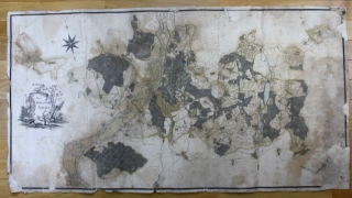

Rare 18th century Atlas of Silesia
HOMANN Erben - Atlas Silesiae id est Ducatus Silesiae Generaliter quator mappis nec non specialiter XVI mappis tot principatus repraesentantibus geographice exhibitus Leipzig, 1750. Zeitgenössischer Halbleder-Einband mit Rückentitel und Rückenvergoldung [64 x 51 x 3 cm].
sold/verkauft

Original Woodcut Blocks
Woodcut Blocks Tarot of Marseilles - Suisse (?), c. 1750.
sold/verkauft
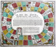
Le Jeu de l’oye, renouvelle des Grecs
Le Jeu de l'oye, renouvelle des Grecs. Toulouse, M. Peyrane, n.d. (c. 1750)
sold
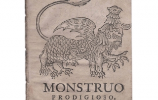
A monster in Chile
Relacao de hum Monstruo prodigioso, que appareceo no Reyno de Chile entre os montes, que dividem este Reino das dilatadas Provoncias de Tucman, e Paraguai, ou do Rio da Prata, que sao confinantes com o Brazil. Lisbon, Miguel Manescal da Costa, 1751. unbound. 4to, 16 pp., with a title-woodcut depicting the monster.
sold
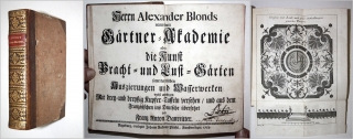
First German edition of a work on formal gardens by Baroque French architect Alexander le Blond
LE BLOND, Alexander and DEZALLIER D'ARGENVILLE, Antoine-Joseph - Neueröfnete Gärtner-Akademie oder: Die Kunst Pracht-und Lust-Gärten samt dererselben Auszierungen und Wasserwerken wohl anzulegen Mit drey-und dreyssig kupfer-Taffeln versehen und aus dem Französischen ins Deutsche übersesset von Franz Anton Danreitter. 4to [183 x 118mm]. Augsburg, 1753. Original half leather with spine label and gold ornaments on spine. (13) 368 (2) pages. 1st German edition. With engraved frontispiece and 36 other copper engravings.
sold
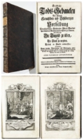
Rentz, Michael Heinrich (1698-1758) und Sporck, Franz Anton Graf von (1662-1738) - Geistliche Todts-Gedancken Bey allerhand Gemählden und Schildereyen In Vorbildung Unterschiedlichen Geschlechts / Alters / Standes / Und Würdens-Persohnen sich des Todes zu erinnern. Erste Ausgabe. Passau, Friedrich Gabriel Mangold / Linz, Franz Anton Ilger, 1753.
sold/verkauft

Armorial Manuscript – Royal European families
„Blason et Armories des maisons souveraines & familles Illustres de l'Europe Commencant par celle de l'Auguste maison d'Austriche". 28 September 1758. Armorial manuscript with the coats of arms of Royal European families. In-folio [ca. 31 x 20 cm].
verkauft/sold