

Europe

Rare 16th century map of Paris
HOGENBERG, Frans; BRAUN, Georg - Lutetia. Köln, 1575. Original Kupferstich aus der französischen Ausgabe von Braun Hogenbergs berühmten Städte-Atlas. Blattmasse: ca. 52 x 41 cm.
EUR 1500,-

Rare large map of Cyprus by Nicolas Sanson
SANSON D'ABBEVILLE, Nicolas (1600-1667) - "Cyprus Insula". Paris, Mariette, c. 1657. Size: ca. 60,5 x 44 cm.
EUR 1.500,-

Rare 17th century Atlas of the Netherlands
Peers, Richard (1645-1690); Pitt, Moses (fl. 1654-1696) - The English atlas volume IV. Containing the description of the Seventeen Provinces of the Low-Countries, or Netherlands. Oxford, 1682.
EUR 6.500,-
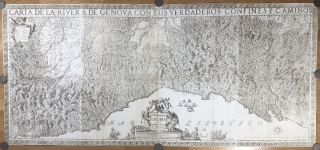
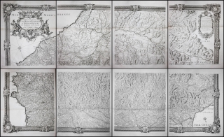
Rare first edition of one of the most important maps of Liguria
CHAFRION, Joseph (1653-1698)- "Carta del la Riviera de Genova con sus verdaderos confines y caminos. / Topographia de la Liguria. Dedicada A L'Excellmo Senor Conde de Melgar del Estado de Milan por D. Joseph Chafrion". Milano, Marc Antonio del Re, 1685.
EUR 4.500,-

Rare 18th century map of Paris
HOMANN, Johann Baptist- Prospect und Grundriss der Weltberühmten Königliche Haupt Stadt Paris samt ihrem Schloß, Universitat und allen herumligenden Vorstadten. Nuremberg, c. 1720. Rare original old-colored engraved map. Size: ca. 62,5 x 54 cm.
EUR 750,-

Original 18th century engraving of Naples by Blaeu & Mortier
BLAEU, Willem Jansz; MORTIER - "Napoli". Rare original engraving by Blaeu / Mortier from 1725. Size of sheet: ca. 113 x 53 cm (circa 44.5 x 20.9 inches).
EUR 1500,-
Large map of the Pyrenees
ROUSSEL, Joseph und Francois de la Blottiere - "Carte Generale des Monts Pyrenées et Parie des Royaumes de France et d'Espagne". Paris, 1730.
EUR 2.900,-

Decorative, highly sought-after rare map of the island of Corfu
SEUTTER, Matthäus - "Nova et exactissima Geographica Delineatio Insulae Corfu seu Corsulae, tanquam..." Augsburg, Seutter. 1741. Platten-Masse ca. 50 x 58 cm. Blatt-Masse ca. 54,5 x 61 cm.
EUR 1250,-

One world map and 4 maps of continents, handcolored and engraved by Georg Christoph Kilian
KILIAN, Georg Christoph - Set of 5 handcolored engraved maps - one world map and 4 continental maps (1759).
EUR 1550,-

Very rare view of the Tivoli waterfall
PIRANESI, Giovanni Battista (1720-1778) - Veduta della Cascata di Tivoli. 1766. First state.
EUR 2.400,-

Folio manuscript world atlas by a young lady
CROUZET, Hortense - Atlas Géographique composé de 11 Cartes. Dessiné par Mlle. Hortense Crouzet eleve de l'Institution de Mlle Roullet pour le concours des prix de l'année 1824. France, 1824. Manuscript Title, 11 folded manuscript maps with outline color. 365 x 245 mm.
EUR 1200,-

Gesamtansicht von Eichstätt – Original Zeichnung von Gustav Kraus
Kraus, Gustav (1804-1852)
Eichstätt von Süden. Um 1829. 27,4 x 38,6 cm
Bisher unbekannte Zeichnung von Gustav Kraus. Prächtige Panorama-Ansicht von Eichstätt.
EUR 4500,-

Original drawing of the medieval castle in the Italian city of Ferrara
E.L.D. (probably Edouard Louis Dubufe?) - Castello Estense a Ferrara. Italy, c. 1840. Original watercolor painting. Format: 267 x 204mm.
EUR 950,-

Extensive collection of drawings of the architectural elements of the Chartres Cathedral
„Cathedrale de Chartres“. 2 volumes with a total of 61 drawings. France, 1840s.
EUR 2.850,-

Souvenirs du Mont-Blanc
CHARLET, A. - Souvenirs du Mont-Blanc. Paris, 1855-1857. Original Leinen-Einband [14,6 x 19 cm]. 23 Farblithographien (14,5 x 18,5 cm), 1 davon doppelseitig (14,5 x 35 cm).
sold/verkauft .

Arctic Voyage
Polarfahrt mit dem D. "Grosser Kurfürst" des Norddeutschen Lloyd vom 27. Juni - 25. Juli 1908. Original-Aufnahmen Atelier Schaul, Hamburg. Album with 73 gelatin silver prints (157 x 222mm). Original red cloth, oblong folio (250 x 355mm)
EUR 1200,-