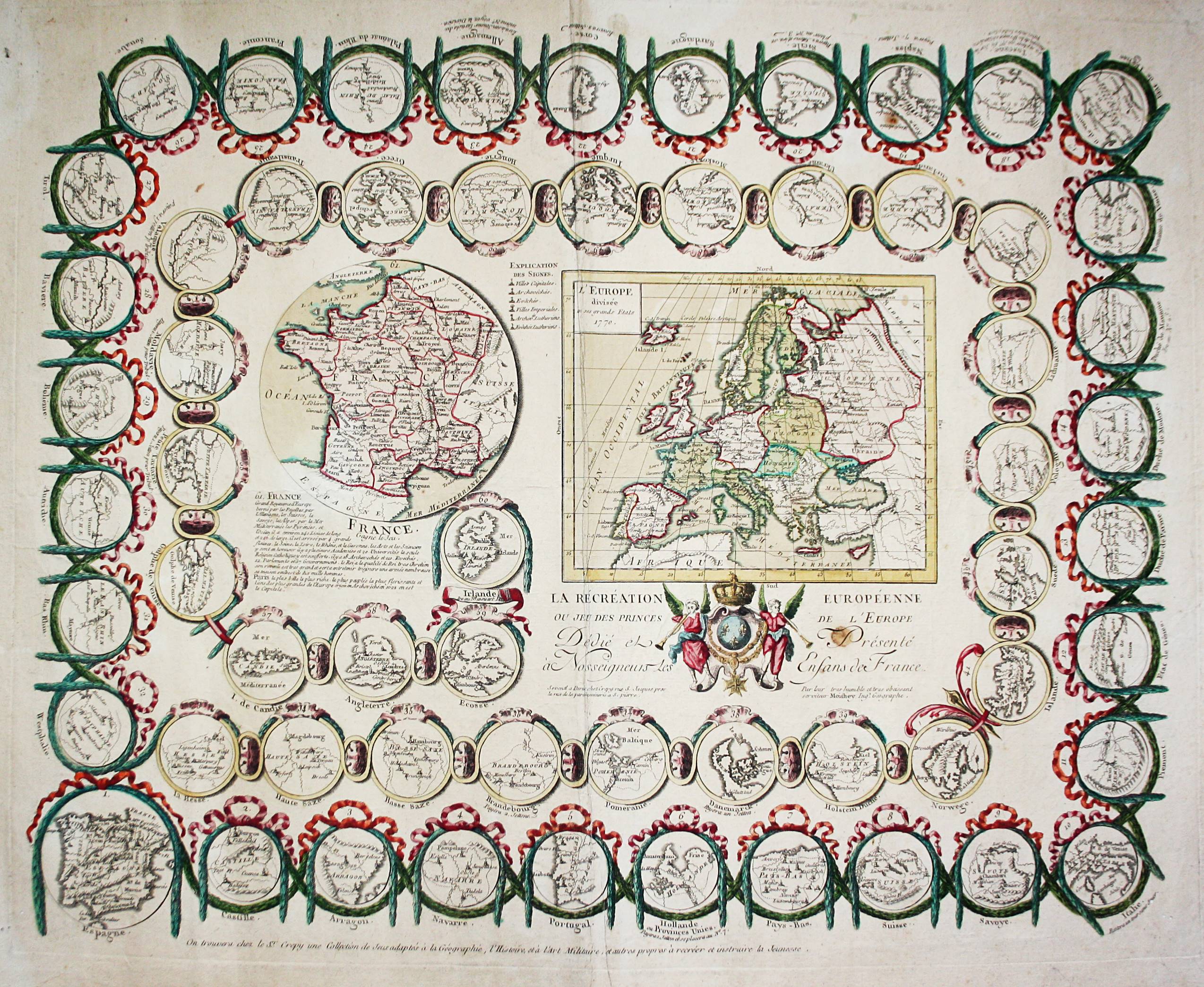
Moithey, Murille-Antoine (1732-1805) – La Recreation Europeenne ou Jeu des princes de l’Europe. Paris, Crepy, 1770.
Plate: 490 x 620 mm; Sheet: 575 x 705 mm; Altkolorierter Kupferstich / Old colored etching.
Sehr seltenes geographisches Würfelspiel (Gänsespiel) mit 61 Spielfeldern. Jedes Feld zeigt eine Landkarte einer europäischen Region, darunter u.a. Sizilien, Sardinien, Korsika, Irland, Island, Polen, Litauen, Ukraine, Kreta, Norwegen, Parma, Modena, Genua, Piemont, Mantua, Venedig, Savoyen, Toskana etc. — in den Außenrändern teils leicht fleckig, mit kleinem Fleck in der Titel-Kartusche, mit drei winzigen Wurmlöchlein in den unteren seitlichen Bildrändern – gut erhalten.
Old colored copper engraving. Very rare geographic board game (game of goose) with 61 playing fields. Each field shows a map of a European region, including Sicily, Sardinia, Corsica, Ireland, Iceland, Poland, Lithuania, Ukraine, Crete, Norway, Parma, Modena, Genova, Piemonte, Mantova, Venezia (Venice), Savoy, Tuscany etc. – Partly slightly stained in the outer margins, with a small stain in the title cartridge, with three very small wormholesin the lower margins – otherwise in very good condition.
Literature: Henry-René D’Allemagne – Le noble jeu de l’oie en France, de 1640 à 1950. Paris, 1950 (p. 94); Adrian Seville – The geographical Jeux de l’Oie of Europe. (In „Belgeo“ 2008 3-4 2008); Adrian Seville – The Game of Goose: and its influence on cartographical race games. (in Journal of the International Map Collectors‘ Society, Winter 2008 N°115 2008); Ömer Fatih Parlak – The Image of the Turk in Early Modern Board Games and Playing Cards.(PHD THESIS). Universitat Autonoma de Barcelona, 2019.
sold/verkauft